

Balkans under risk of storms and extreme weather - over the weekend
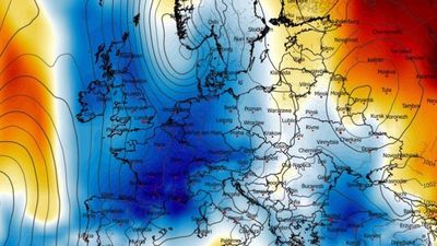
A powerful atmospheric system is causing major changes in the weather over Europe, bringing cold air from the north to the south that creates conditions for a period of extreme weather in some regions, warns the Severe Weather Europe meteorological service.
According to forecasts, the collision of the cold mass with warm, humid air over the Mediterranean is creating favorable conditions for strong storms, including supercells, large hail, and local flooding.
The most at-risk areas include northern Italy, the Adriatic coast and parts of the western Balkans, where organized storms and intense rainfall are expected, especially in mountainous areas.
Meteorologists point out that the changes have been driven by a high-pressure system over the North Atlantic, which has allowed cold air masses to penetrate central and southern Europe.
This has led to the formation of a powerful cyclone that is causing a significant drop in temperatures.
In some regions of western and southwestern Europe, temperatures are expected to drop to 10–14°C below the seasonal average, with mornings bringing near-zero temperatures and a risk of frost. Even during the day, temperatures will remain significantly below normal.
According to forecasts, snowfall of up to 50 centimeters is expected in the Alps, while some areas of the Balkans and Italy may record over 100–150 mm of rainfall within a few days.
However, meteorologists predict that the situation will begin to change over the next week, when the cold system is expected to weaken and higher temperatures are expected to gradually return, with even the possibility of a new wave of warm weather towards the end of the month. /Telegraph/